Easy Drone Hire
DSR is the UK’s largest drone hire and specialist camera services website.
We proudly market the nation’s top drone professionals who are all Civil Aviation Authority (CAA) qualified and insured to carry out commercial drone work.
Each week DSR publishes a weekly news blog to keep our members and the wider drone community up to date with industry related news. We aim to keep both professional and drone hobby readers informed with the UK’s latest drone news, laws and regulations. We hope that our blogs inform both hobby and professional drone users. We recognise people that use drones for leisure may well be the commercial operators of drones tomorrow.
We also post items that support our pro members who are all CAA qualified and insured, professional drone pilots. We strive for better safety in our skies and press for tougher penalties for illegal drone operators that commercially fly without the legal certification and insurance.
Drones offer great potential and can clearly be a lot of fun, but often attract headlines for the wrong reasons. As the drone community grows it is in everyone’s interests to promote responsible and safe use of this exciting new technology. Remember, individually as responsible drone pilots we are all ambassadors to the drone community as a whole.
The UK’s aviation rules are set by the CAA. UK law stipulates that any drone pilot who is operating for commercial gain must have the mandatory CAA permissions. It is a criminal offence to operate professionally without the CAA’s permission for commercial operation certification. This is known as a PFCO.
As responsible drone pilots, safety in our skies is top priority. Drone users, when taking to the skies, are entering one of the busiest areas of airspace in the world – a complex system that brings together all manner of aircraft including passenger aeroplanes, military jets, helicopters, gliders, light aircraft and now drones.
Last year there were 59 cases involving drones and aircraft and the government has already made the rules around flying drones more simple in an effort to improve drone safety.
A recent survey by the UK’s CAA found that 60% of drone owners did not know about the safe flying rules in the drone code.
In a recent BBC news item Jonathan Nicholson from the Civil Aviation Authority (CAA) told the BBC:
“A lot of the advice is common sense; Don’t fly above 400ft (120m), you need to be able to see it and keep it in sight, don’t fly it near airports, airfields and aircraft and keep it 160ft (50m) away from people who aren’t under your control.”
In recent years, the CAA have heard of several incidents where drones are being flown too close to aircraft – primarily because people are flying drone out of their line of sight and too high. On each occasion, the drone users appeared to be flying the devices well above drone height limits, with some reported as high as 2,000 ft from ground level and in areas where large aircraft are present.
This prompted the CAA to join together with other leading aviation bodies to remind users of the importance of following the clear safety rules that are in place – with a focus on making sure users always keep devices well within their ‘visual line of sight’ (a maximum height of around 400ft).
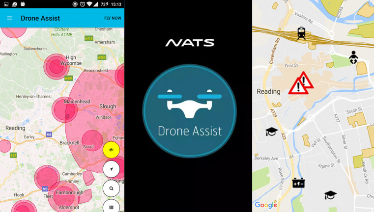
Drone Assist
Drone Assist is an app created by the National Air Traffic Control Service (NATS, the UK’s main air traffic control provider). It tells drone owners if they are flying in or near restricted airspace.
Drone Assist provides location-based information on areas of airspace to avoid or in which extreme caution should be exercised, as well as on ground hazards that may pose safety, security or privacy risks.
Many drone pilots don’t realise that there are rules, set by the UK CAA, for where and how you can fly your drone. This app will help you to abide by those rules, providing a tool to assist you in enjoying flying your drone whilst protecting your safety and the safety of other airspace users.
Here are the app features:
View areas of controlled airspace, such as airfields and airports, where flying a drone could be hazardous or prohibited
View ground hazards, such as schools, overhead power lines and sports venues, flying close to which may raise security, privacy or safety concerns and could breach UK rules on drone flying
Drone Assist is the new drone safety app from NATS, the UK’s main air traffic control provider, powered by Altitude Angel. It presents users with an interactive map of airspace used by commercial air traffic so that you can see areas to avoid or in which extreme caution should be exercised, as well as ground hazards that may pose safety, security or privacy risks when you’re out flying your drone.
It also contains a ‘Fly Now’ feature that enables you to share your drone flight location with other app users and the wider drone community, helping to reduce the risk of a drone related incident in the UK’s airspace.


